Biodiversity of the Rusizi National Park
Protected area
The biodiversity of the Rusizi National Park
Ten thousand six hundred and seventy-three hectares of palm grove, marshland and delta, at the gates of Bujumbura. What the official sources say about what lives there, what threatens it and what protects it.
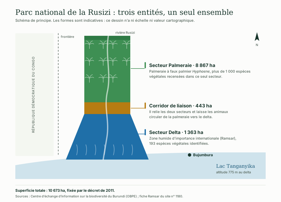
Illustration: ACAPE Burundi. Data: CHM Burundi (OBPE) and Ramsar Information Sheet no. 1180.
Every figure comes from a named, verifiable source, cited at the foot of the page. Where two official sources contradict each other — and that is the case for the area and for the number of birds — both versions are given, without choosing between them.
The illustrations were drawn for this page by ACAPE Burundi. They are schematic: none of them is a map or a field survey.
The park extends across the Rusizi plain, north of the Imbo natural region and of Lake Tanganyika, in the provinces of Bubanza and Bujumbura. It is managed by the Burundian Office for the Protection of the Environment.
The park at a glance
Six markers to place it
The data below come from the Burundi Biodiversity Clearing-House Mechanism and from the site’s Ramsar Information Sheet.
10 673 hectares
Set by the 2011 decree and carried over onto the Ramsar Information Sheet.
Three units
Palm grove 8 867 ha, delta 1 363 ha, connecting corridor 443 ha.
Ramsar Site no. 1180
Listed on 5 June 2002 as a wetland of international importance.
350 species
Resident and migratory, according to CHM Burundi.
More than 1 000 species
In the Palm Grove sector alone; 193 species identified in the delta.
775 metres
Mean altitude recorded at the delta.
The habitats
From the river to the lake
The palm grove, the grasslands, the marshes and the delta follow one another along the Rusizi as far as Lake Tanganyika.
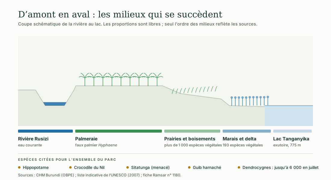
Illustration: ACAPE Burundi. Data: CHM Burundi (OBPE), UNESCO tentative list (2007), Ramsar Information Sheet no. 1180.
The Palm Grove sector takes its name from the doum palm Hyphaene benguellensis var. ventricosa. The dossier submitted by Burundi to the World Heritage tentative list in 2007 describes some 1 200 hectares of palm grove along the river and states that the seeds of this tree, known as « vegetable ivory », are found nowhere else in the country at this concentration.
The Delta sector is the wet part, where the Rusizi flows into Lake Tanganyika. It is this complex of permanent inland delta, freshwater lakes, rivers and marshes that earned the site its listing under the Ramsar Convention.
What lives there
The recorded fauna and flora
Expand a group to see the species named by the sources. No species has been added to these lists.
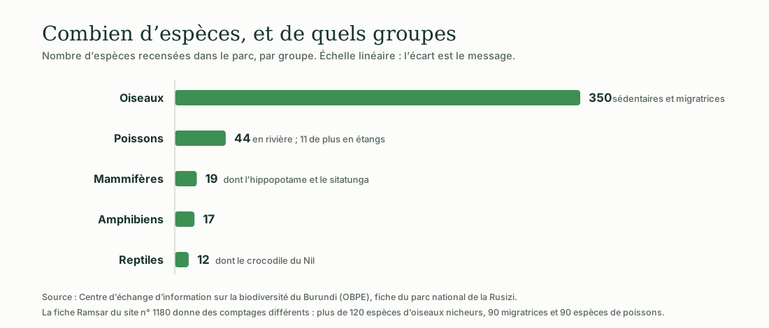
Illustration: ACAPE Burundi. Data: CHM Burundi (OBPE); the differing counts in Ramsar Information Sheet no. 1180 are recalled on the figure.
Mammals · 19 species
The hippopotamus (Hippopotamus amphibius) is the park’s emblematic species. The bushbuck (Tragelaphus scriptus) and the sitatunga (Tragelaphus spekii) are also recorded there; the sitatunga, a swamp antelope, is reported as threatened by the Burundi Biodiversity Clearing-House Mechanism.
Birds · 350 species
CHM Burundi records 350 resident and migratory species. The whistling ducks (Dendrocygna viduata and Dendrocygna bicolor) form the most spectacular gatherings: their numbers can reach 6 000 individuals in July.
The site’s Ramsar Information Sheet, which is older, counts differently: more than 120 breeding species and 90 migratory species. Both figures coexist in official documents; neither has been chosen over the other on this page.
Reptiles · 12 species
The Nile crocodile (Crocodylus niloticus) and the West African mud turtle (Pelusios castaneus), a freshwater turtle, are among the species cited.
Fish · 44 species in the river, 11 in ponds
The marbled lungfish (Protopterus aethiopicus), a lunged fish able to survive the drying out of its habitat, is reported among these species. The Ramsar Information Sheet, for its part, gives 90 fish species for the site.
Amphibians · 17 species
CHM Burundi gives the number without listing the species. This page does not fill that gap.
Flora · more than 1 000 species
More than 1 000 plant species are recorded in the Palm Grove sector alone, and 193 in the delta. The doum palm Hyphaene benguellensis var. ventricosa gives the park its unique character in the country.
Legal status
A park, a reserve, then a park again
The boundaries and the status of the site have changed several times since 1980. The areas reported vary with them.
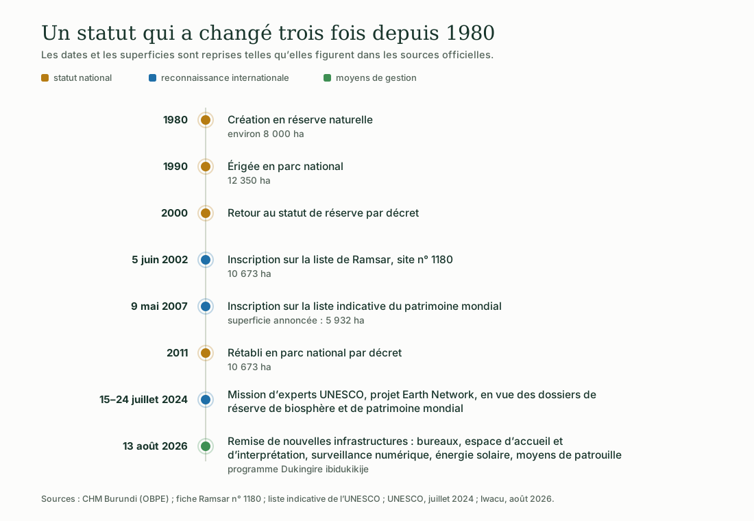
Illustration: ACAPE Burundi. Data: CHM Burundi (OBPE), Ramsar Information Sheet no. 1180, UNESCO tentative list, UNESCO (July 2024), Iwacu (August 2026).
Why the reported areas do not agree
Four values circulate in official documents: about 8 000 hectares when it was created in 1980; 12 350 hectares when it was raised to national park in 1990; 5 932 hectares in the dossier submitted to UNESCO in 2007; 10 673 hectares since the 2011 decree, a figure also carried on the Ramsar Information Sheet.
These differences reflect successive redrawings of the boundaries, not measurement errors. The value in force today is the one in the 2011 decree: 10 673 hectares.
The French-language Wikipedia page on the park gives 5 932 hectares in its text and 9 000 hectares in its infobox: these figures are not used here, since the source contradicts itself.
Where the UNESCO nomination stands
The site has been on the World Heritage tentative list since 9 May 2007, under natural criteria (vii) and (ix). Being on this list is not the same as being inscribed: it is a declaration of intent to apply.
From 15 to 24 July 2024, an expert mission supported by the Earth Network project and funded by the Italian government worked with OBPE and the National Commission for UNESCO on preparing the nomination dossiers, for the Rusizi as well as for the Kibira, as a biosphere reserve and as a World Heritage property. To date, neither of these two inscriptions has been secured.
Pressures and responses
What threatens, what protects
The pressures recorded from park staff in 2023, and the resources handed over to the park in August 2026.
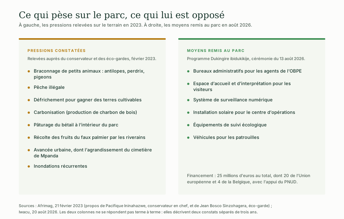
Illustration: ACAPE Burundi. Data: Afrimag (February 2023) and Iwacu (August 2026).
The two columns do not answer each other term for term. Three years separate the two accounts, and none of the sources consulted measures the effect of the resources provided in 2026 on the pressures described in 2023. This page therefore does not claim any.
For the course
What the Rusizi teaches
Proposal by ACAPE Burundi: this site serves as a concrete example for three ideas in the course.
Biodiversity
A single site brings together 350 bird species and more than 1 000 plant species. It shows what the word « biodiversity » covers in a way that no definition can.
Water and wetlands
The delta is a wetland recognised at international level. It illustrates the role of such habitats in the life of a river and of a lake.
Environmental citizenship
The pressures listed here — land clearing, charcoal burning, grazing — are everyday acts. They raise the question of shared rules and of what each person can do.
Burundi Biodiversity Clearing-House Mechanism (OBPE), Rusizi National Park factsheet · Convention on Wetlands, Ramsar Site no. 1180 Information Sheet, listed 5 June 2002 · UNESCO, World Heritage tentative list, dossier submitted 9 May 2007 · UNESCO, expert mission 15–24 July 2024 (Earth Network project) · Afrimag, 21 February 2023 · Iwacu, 20 August 2026.
See the five illustrations · Burundi, a treasure house · Take the environmental training course
The illustrations on this page were produced by ACAPE Burundi from these sources. They may be reused and adapted, provided that ACAPE Burundi and the data sources are cited.