Biodiversity of the Kibira National Park
Protected area
The biodiversity of the Kibira National Park
Eighty kilometres of mountain forest along the Congo-Nile ridge. Burundi’s largest forest, its water tower, and half of what it was ninety years ago.
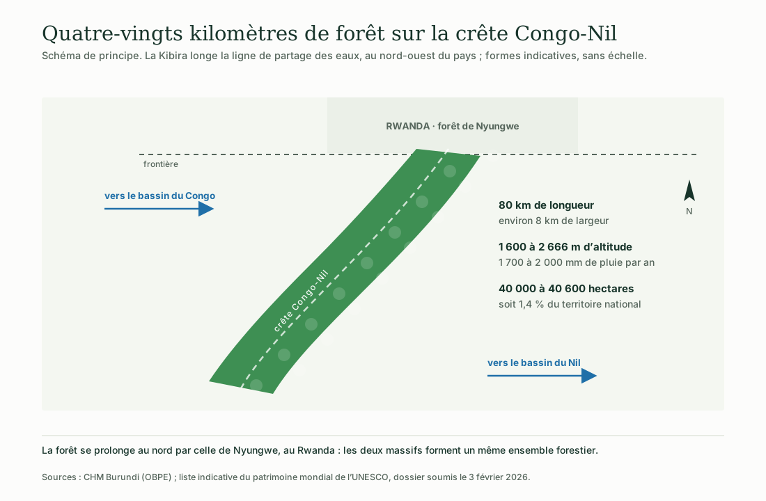
Illustration: ACAPE Burundi. Data: CHM Burundi (OBPE); UNESCO tentative list, dossier submitted 3 February 2026.
Every figure comes from a named source, cited at the foot of the page. Where the sources diverge — and they diverge on the area — both values are given.
The illustrations were drawn for this page by ACAPE Burundi. They are schematic: none of them is a map.
The Kibira occupies the north-west of the country and continues northwards into the Nyungwe forest, in Rwanda: the two massifs form a single forest complex. The park is managed by the Burundian Office for the Protection of the Environment.
The park at a glance
Six markers to place it
Data from the Burundi Biodiversity Clearing-House Mechanism and from the dossier submitted to UNESCO in February 2026.
40 000 to 40 600 ha
40 000 ha according to CHM Burundi, 40 600 ha according to the 2026 UNESCO dossier, that is 1.4% of the national territory.
80 km long
For a width of about 8 km, along the Congo-Nile ridge.
1 600 to 2 666 m
The forest rises on average to 2 500 metres.
1 700 to 2 000 mm
Per year. The park regulates the waters of the Imbo plain and of the neighbouring plateaux.
98 species
Including the eastern chimpanzee and about ten primate species.
More than 644 species
Including 60 of Burundi’s 70 endemic forest species.
Vegetation
What altitude changes
The forest changes with altitude, but the sources do not say where each boundary lies.
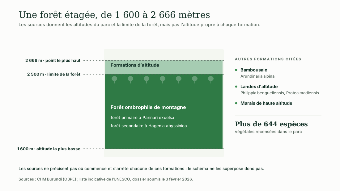
Illustration: ACAPE Burundi. Data: CHM Burundi (OBPE); UNESCO tentative list (3 February 2026).
The primary forest is dominated by Parinari excelsa, the secondary forest by Hagenia abyssinica. To these are added a bamboo stand of Arundinaria alpina, high-altitude heathland of Philippia benguellensis and Protea madiensis, and high-altitude marshes.
The sources do not state the altitude specific to each of these formations. The diagram therefore does not stack them: it only places the two known limits, 2 500 metres for the forest and 2 666 metres for the high point.
Water
Where the waters part
The ridge that crosses the park separates the waters of the Congo basin from those of the Nile basin.
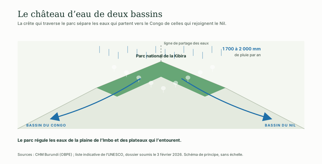
Illustration: ACAPE Burundi. Data: CHM Burundi (OBPE); UNESCO tentative list (3 February 2026).
With 1 700 to 2 000 millimetres of rain a year, the massif acts as a water regulator for the Imbo plain and the surrounding plateaux. This is one of the arguments put forward in the dossier submitted to UNESCO, which speaks of a water tower for the basins of Central and East Africa.
What lives there
The recorded fauna
A note on reading these figures: primates, insectivores and bats are part of the 98 species, they are not added to them.
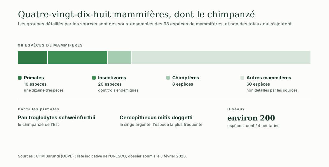
Illustration: ACAPE Burundi. Data: CHM Burundi (OBPE); UNESCO tentative list (3 February 2026).
Primates · about ten species
The eastern chimpanzee (Pan troglodytes schweinfurthii) is the park’s most emblematic species. The silver monkey (Cercopithecus mitis doggetti) is the most frequently observed.
Insectivores · 20 species
Three of them are reported as endemic: Myosorex blarina, Crocidura lasona and Crocidura niobe.
Other mammals
The bushbuck, the bushpig, the yellow-backed duiker, the black-fronted duiker, the serval, the side-striped jackal and the civet are among the species named. The park also has eight bat species.
Birds · about 200 species
Among the notable species cited: Lophaetus occipitalis, Corythaeola cristata and Bycanistes subcylindricus. The park is home to fourteen sunbird species.
Reptiles
Two snakes are named by CHM Burundi: Atheris nitschei and Bitis gabonica. No total is given for reptiles.
Amphibians and fish
CHM Burundi states that, for these two groups, « the studies remain to be done ». This page therefore puts forward no figure.
Endemism
The legacy of the Albertine Rift
The Kibira belongs to the Albertine Rift, one of the centres of endemism on the African continent.
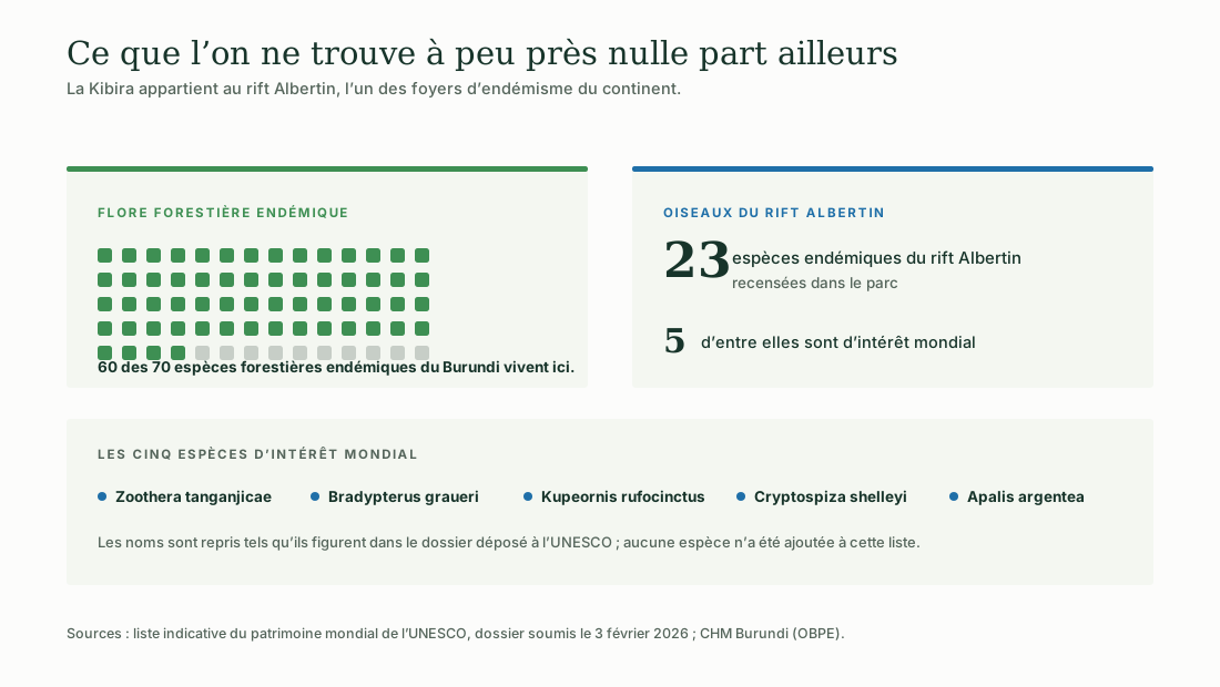
Illustration: ACAPE Burundi. Data: UNESCO tentative list (3 February 2026); CHM Burundi (OBPE).
Sixty of Burundi’s seventy endemic forest species live in this park alone. Among birds, twenty-three species endemic to the Albertine Rift are recorded there, five of them of global importance.
Pressure
What the forest has lost
A study published in November 2025 puts the area at 90 000 hectares for 1933.
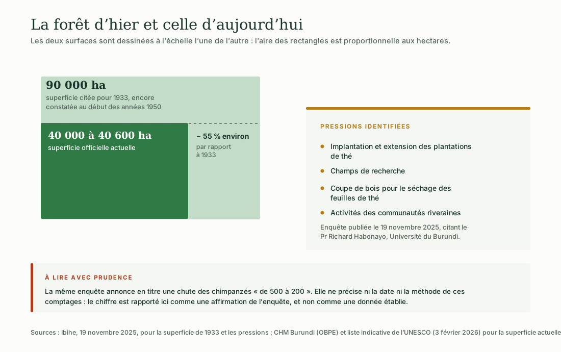
Illustration: ACAPE Burundi. Data: Ibihe, 19 November 2025; CHM Burundi (OBPE); UNESCO tentative list (3 February 2026).
The investigation by the outlet Ibihe, which quotes Professor Richard Habonayo of the University of Burundi, puts the area at 90 000 hectares in 1933, still recorded in the early 1950s. Set against today’s official 40 000 to 40 600 hectares, the difference approaches 55%.
The pressures identified by this investigation are the establishment and expansion of tea plantations, research plots, the cutting of wood to dry tea leaves, and the activities of the neighbouring communities.
The same investigation announces in its headline a fall in chimpanzees « from 500 to 200 ». Neither the date nor the method of these counts is stated: the figure is reported here as a claim made by that investigation, not as established data.
Recognition
A World Heritage nomination
Burundi submitted a dossier for the Kibira at the start of 2026.
Where the nomination stands
The park has been on the UNESCO World Heritage tentative list since 3 February 2026, under natural criteria (viii), (ix) and (x).
Being on this list is not the same as being inscribed: it is a declaration of intent to apply. The dossier highlights the geological formation of the Congo-Nile ridge, the massif’s role as a water tower, and a mountain forest ecosystem that has remained intact, with marked altitudinal zonation.
An expert mission supported by the Earth Network project worked from 15 to 24 July 2024 with OBPE and the National Commission for UNESCO on preparing the dossiers for the Kibira and the Rusizi. To date, no inscription has been secured.
For the course
What the Kibira teaches
Proposal by ACAPE Burundi: three ways into the modules of the course.
Biodiversity
Sixty endemic forest species out of the country’s seventy: a textbook case for understanding what endemism is and why it makes a place irreplaceable.
Water and wetlands
A mountain forest that feeds two continental basins: the clearest illustration of the link between forest cover and water resources.
Reforestation and restoration
The comparison between 1933 and today raises the question of what is lost, what can be restored, and what cannot.
Burundi Biodiversity Clearing-House Mechanism (OBPE), Kibira National Park factsheet · UNESCO, World Heritage tentative list, dossier submitted 3 February 2026 · UNESCO, expert mission 15–24 July 2024 (Earth Network project) · Ibihe, 19 November 2025.
See the six illustrations · Biodiversity of the Rusizi National Park · Take the environmental training course
The illustrations on this page were produced by ACAPE Burundi from these sources. They may be reused and adapted, provided that ACAPE Burundi and the data sources are cited.