Biodiversity of the Ruvubu National Park
Protected area
The biodiversity of the Ruvubu National Park
Fifty thousand eight hundred hectares of savannah and gallery forest along the river of the hippopotamuses. What the sources say about what lives there, and about the summer when a fifth of the park burned.
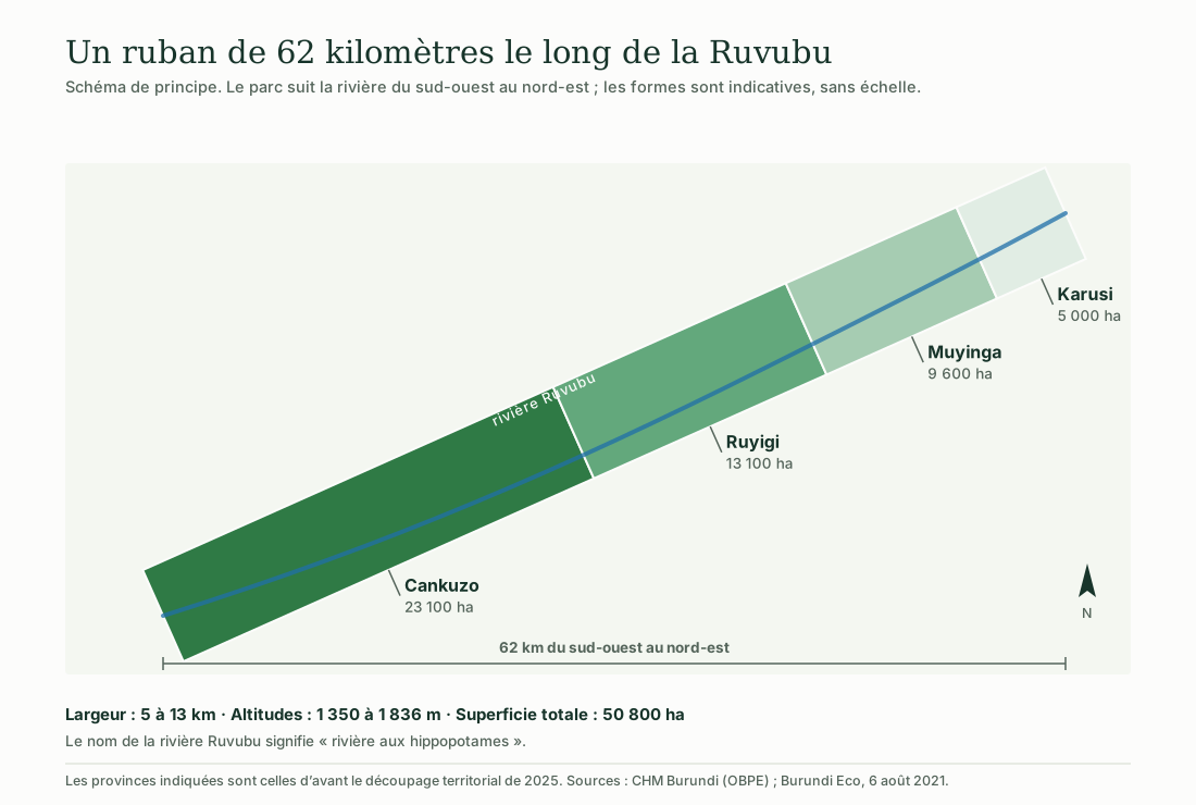
Illustration: ACAPE Burundi. Data: CHM Burundi (OBPE); Burundi Eco, 6 August 2021.
Every figure comes from a named source, cited at the foot of the page. Where the sources diverge — and they diverge on the number of birds as well as on the area — both values are given.
The illustrations were drawn for this page by ACAPE Burundi. They are schematic: none of them is a map.
The park lies in the east of the country, running 62 kilometres from south-west to north-east, with a width of 5 to 13 kilometres, between 1 350 and 1 836 metres of altitude. It is managed by the Burundian Office for the Protection of the Environment.
The park at a glance
Six markers to place it
Data from the Burundi Biodiversity Clearing-House Mechanism and from the Ramsar Information Sheet.
50 800 hectares
CHM Burundi also mentions 50 900 ha; the Ramsar Information Sheet keeps 50 800.
62 km long
For a width of 5 to 13 km, along the Ruvubu river.
1 350 to 1 836 m
On the plateaux of eastern Burundi.
Ramsar Site no. 2148
Listed on 14 March 2013 as a wetland of international importance.
Four provinces
Cankuzo, Ruyigi, Muyinga and Karusi, under the administrative division in force before 2025.
421 species
According to CHM Burundi; other sources count 425.
Territory
Straddling four provinces
The park belongs to no province in particular: it runs across them.
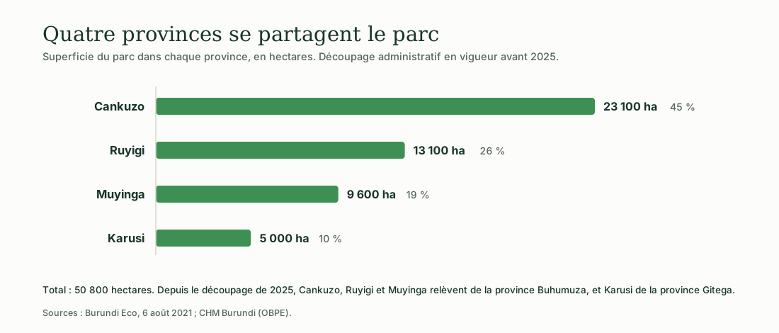
Illustration: ACAPE Burundi. Data: Burundi Eco, 6 August 2021; CHM Burundi (OBPE).
The available figures predate the territorial reorganisation of 2025. Since then, Cankuzo, Ruyigi and Muyinga fall under Buhumuza province, and Karusi under Gitega province. None of the sources consulted restates the distribution under the new division; it is therefore not recalculated here.
Vegetation
What grows on these plateaux
Savannah is largely dominant, dotted with woodland, gallery forest and marshes.
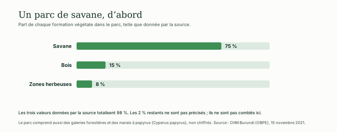
Illustration: ACAPE Burundi. Data: CHM Burundi (OBPE), 15 November 2021.
To the three formations for which figures exist must be added, in unknown proportions, the gallery forests that follow the river and the papyrus marshes (Cyperus papyrus).
What lives there
The recorded fauna
Expand a group to see the species named by the sources.
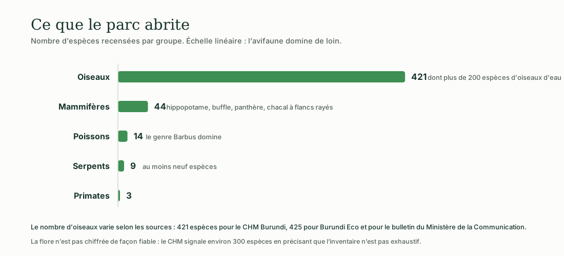
Illustration: ACAPE Burundi. Data: CHM Burundi (OBPE); Burundi Eco, 6 August 2021.
Mammals · 44 species
The hippopotamus (Hippopotamus amphibius) gave the river its name: Ruvubu means « river of the hippopotamuses ». The buffalo (Syncerus caffer), the leopard (Panthera pardus) and the side-striped jackal (Canis adustus) are among the species cited, together with the defassa waterbuck and the sitatunga.
Birds · 421 species
CHM Burundi records 421 species, including more than 200 waterbird species, and reports the presence of migratory birds from Europe.
Burundi Eco and the bulletin of the Ministry of Communication give 425 species for their part. The gap is small but real; both values are kept as they stand.
Reptiles
The Nile crocodile (Crocodylus niloticus) is present in the river. CHM Burundi reports at least nine snake species, without giving a total for reptiles.
Fish · 14 species
The genus Barbus dominates the inventory.
Amphibians
Three species are named by CHM Burundi: Ptychadena uzunguensis, Ptychadena loveridgei and Bufo maculatus. No total is given.
Flora
About 300 plant species are reported, with CHM Burundi itself stating that this inventory is not exhaustive. The figure is therefore a floor, not a total.
History
From hunting ground to Ramsar site
The park took forty years to become what it is. Some of those steps came at a high cost to the people living nearby.
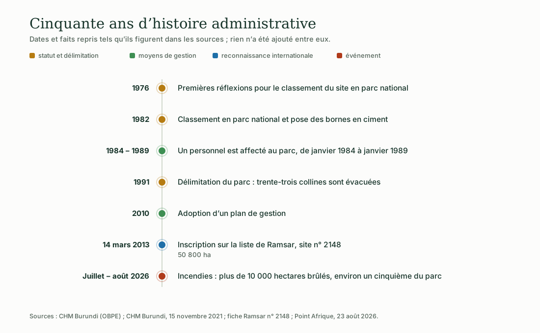
Illustration: ACAPE Burundi. Data: CHM Burundi (OBPE); Ramsar Information Sheet no. 2148; Point Afrique, 23 August 2026.
The thirty-three hills evacuated in 1991
The demarcation of the park, in 1991, was accompanied by the evacuation of thirty-three hills. The fact is reported by the Burundi Biodiversity Clearing-House Mechanism.
None of the sources consulted states how many households were affected, or whether they were compensated or resettled. This page does not fill that silence, but neither does it pass over it.
Why 50 800 and not 50 900 hectares
CHM Burundi mentions both values. The Ramsar Information Sheet, like all the recent sources, keeps 50 800 hectares: that is the value used on this page.
In the news
Summer 2026: a fifth of the park burned
Fires that broke out from the end of July 2026 destroyed more than ten thousand hectares.
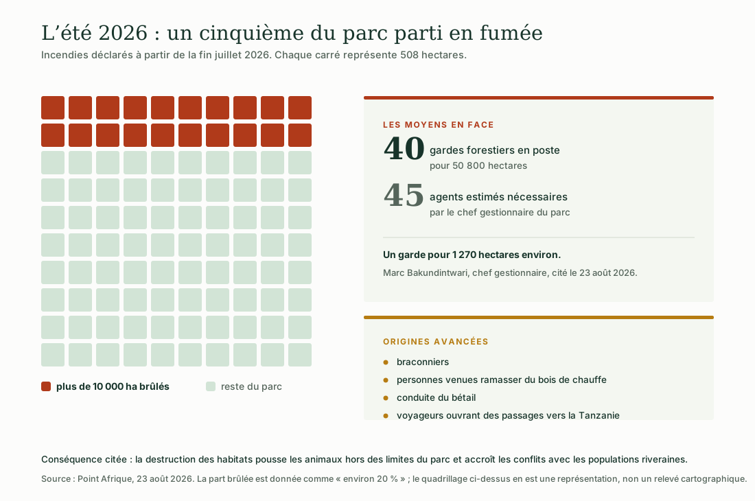
Illustration: ACAPE Burundi. Data: Point Afrique, 23 August 2026.
The park’s chief manager, Marc Bakundintwari, says he has forty forest rangers for the whole of the 50 800 hectares, where about forty-five would be needed. Several origins are put forward for the fires and none is established: poachers, firewood collection, driving livestock, opening up routes towards Tanzania.
Reported consequence: the destruction of habitats pushes animals beyond the park boundaries and increases conflict with the neighbouring population.
Visiting
What a visit costs and brings in
The figures below date from 2021; they have not been updated since by the sources consulted.
Prices, revenue and accommodation in 2021
Prices: 5 000 FBu for a Burundian visitor, 20 000 FBu for a foreign visitor, 50 000 FBu per hour for a trip on the river.
Revenue: 600 000 to 700 000 FBu a month from entrance fees alone; 5 to 6 million FBu including fines.
Accommodation: a single hotel in service, the Gasave lodge, which has six rooms.
Staff: 63 employees in total in 2021, including ten forest rangers for the Muremera sector alone, equipped with rudimentary means against poaching.
For the course
What the Ruvubu teaches
Proposal by ACAPE Burundi: three ways into the modules of the course.
Biodiversity
Four hundred and twenty-one bird species on a single site: enough to give concrete content to the notion of species richness.
Introduction to the environment
The fires of 2026 show in a single season what human pressure does to a habitat, and how it then comes back to the people who live there.
Environmental citizenship
Forty rangers for fifty thousand hectares: protecting a protected area does not hold without the people living around it.
Burundi Biodiversity Clearing-House Mechanism (OBPE), Ruvubu National Park factsheet and article of 15 November 2021 · Convention on Wetlands, Ramsar Site no. 2148 Information Sheet, listed 14 March 2013 · Burundi Eco, 6 August 2021 · Point Afrique, 23 August 2026 · 2025-2026 annual bulletin of the Ministry of Communication and Media.
See the six illustrations · Biodiversity of the Rusizi National Park · Take the environmental training course
The illustrations on this page were produced by ACAPE Burundi from these sources. They may be reused and adapted, provided that ACAPE Burundi and the data sources are cited.